Cabins in Duck CreekDuck Creek Village · Utah 435-269-9416— Local Agent
Destinations · Elev. 8,400 ft · Southern Utah

Explore Duck Creek Village
& Surrounding Area

Your complete guide to national parks, wilderness, canyon country, and mountain escapes — all within a short drive of your cabin.

Duck Creek Area Guide — Call Shauna 435-269-9416 Direct line · no forms · no follow-up emails.
Shauna Mack, REALTOR® — Duck Creek cabin specialist
Shauna Mack REALTOR® Duck Creek Cabin Specialist Utah Lic. #12212713-SA00
Pine Time Properties

Interactive Area Map

What's Around You

Duck Creek Village sits at the heart of some of Utah's most dramatic scenery. Here's everything within reach — from 5-minute walks to 90-minute drives worth every mile.

Duck Creek Village Area Map — CabinsinDuckCreek.com

Buying or selling in this area?

Every road and neighborhood on this map — a local agent knows them all.

Whether you're thinking about buying a cabin, evaluating what yours is worth, or ready to sell — one call gets you honest, local guidance with no pressure.

Duck Creek Cabin Specialist 435-269-9416 Direct line · no obligation

Open daily · 8am – 8pm MT

Drive times approximate. May vary by season and road conditions. Not to scale.

8,400′ Duck Creek Elevation
2 National Parks Nearby
5 min Closest Natural Site
13+ Destinations on This Map

Live Conditions · Duck Creek Village, Utah

Local Fishing Conditions

Utah DWR Weekly Report →

Today's Fishing Outlook

Loading conditions…

Current Conditions at 8,400′

Air Temp

Wind

Sky

Precip (24h)

Nearby Waters

Navajo Lake ~10 mi · Rainbow & Brown trout
Panguitch Lake ~30 mi · Rainbow trout
Duck Creek Walk-in · Brook & Brown trout
Swains Creek Walk-in · Brook trout

Weather data from Open-Meteo for Duck Creek Village (37.50°N, 112.66°W). Fishing outlook is based on surface conditions only — always check Utah DWR stocking schedules and current regulations before fishing. A Utah fishing license is required.

All Destinations

13 locations
National Park
Bryce Canyon National Park
~1 Hour
One of Utah's crown jewels — a high-plateau amphitheater packed with thousands of crimson hoodoos eroded into surreal shapes. Sunrise from Bryce Point or Sunrise Point is a must.
  • 🗺️Route: Head east on Hwy 14, south on Hwy 89 toward Panguitch, then east on Hwy 12 to the park entrance.
  • 🎟️Entry Fee: $35/vehicle (7-day pass). America the Beautiful Pass accepted.
  • 🥾Top Hikes: Navajo Loop (1.3 mi, strenuous), Queens Garden Trail (2.5 mi), Rim Trail (11 mi, easy).
  • 📅Best Seasons: May–October for hiking; December–March for snowshoeing among hoodoos.
  • 🌡️Altitude: 8,000–9,100 ft — comparable to Duck Creek. Layers still required.
  • 🅿️Parking: Visitor Center lot fills by 9 AM in peak summer. Use the shuttle from 8 AM–8 PM.
Local Tip Book a stargazing program through the park — Bryce Canyon is a Gold-Tier International Dark Sky Park and the night sky is extraordinary.
National Park
Zion National Park
1–1 hr 25 min
Utah's most-visited park. Towering sandstone cliffs, the Virgin River Narrows, and the legendary Angels Landing await. Approximately 1 hour to the East Entrance; 1 hr 15–25 min to the main canyon via Hwy 9.
  • 🗺️Route: South on Hwy 14 to Hwy 89, then west on Hwy 9 through Mt. Carmel Junction into the main canyon.
  • 🎟️Entry Fee: $35/vehicle (7-day pass). America the Beautiful Pass accepted.
  • 🥾Top Hikes: The Narrows (bottom-up, varies), Angels Landing (5.4 mi — permit required), Emerald Pools (1.2–3 mi).
  • 🚌Shuttle: Required in main canyon March–November. No private vehicles past the Visitor Center.
  • ⚠️Permits: Angels Landing and The Narrows overnight require advance lottery permits via recreation.gov.
  • 📅Crowds: Peak season is April–October. Arrive before 7 AM or after 3 PM to beat crowds.
Local Tip The east entrance (via Hwy 9 tunnel) is often less congested and offers a completely different view of the park. Great side-canyon hikes near the east entrance too.
National Monument
Cedar Breaks National Monument
20–25 min
A high-altitude amphitheater of brilliant orange, red, and purple rock — like a miniature Bryce Canyon at 10,000 feet. Far fewer crowds, spectacular wildflowers in July.
  • 🗺️Route: West on Hwy 14 toward Cedar City. The monument is accessible from Hwy 148.
  • 🎟️Entry Fee: $20/vehicle (7-day pass). America the Beautiful Pass accepted.
  • 🥾Top Hikes: Alpine Pond Trail (2 mi loop), Spectra Point / Ramparts Overlook (4 mi).
  • ❄️Season: Road typically open June–October. Snowshoeing and cross-country skiing in winter.
  • 🌸Wildflowers: Mid-July is peak bloom — Indian paintbrush, columbine, and larkspur fill the meadows.
  • 🌡️Elevation: 10,000–10,469 ft. Significantly cooler than the valley — bring a jacket even in summer.
Local Tip Much less visited than Bryce or Zion. Weekday mornings offer near-solitude at the rim overlooks with equally dramatic views.
Natural Feature · Lake
Aspen-Mirror Lake
~5 min + walk
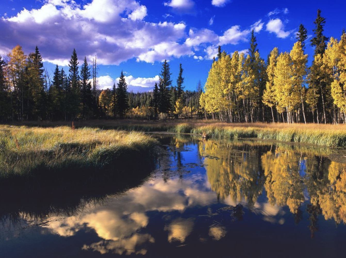
A serene alpine lake surrounded by aspen groves, just minutes from the village center. Perfect for a quiet morning walk, photography, or letting the kids explore the shoreline.
  • 🚶Access: Short drive from village center, then an easy short walk to the lake's edge.
  • 🍂Best Season: Fall foliage (late September/early October) turns the surrounding aspens brilliant gold.
  • 📸Photography: Morning light and still water create perfect reflections of the surrounding forest and sky.
  • 🎣Fishing: Stocked with rainbow trout. Utah fishing license required. Catch-and-release encouraged.
  • 🐾Dogs: Permitted on leash. Keep near water — watch for wildlife at dusk and dawn.
Local Tip Go at first light for glassy water reflections before afternoon winds pick up. The aspen grove along the south shore is one of the most photographed spots in the area.
Natural Feature · Waterfall
Cascade Falls
~20 min
A dramatic waterfall hidden within a lush canyon — water cascades directly out of a limestone cliff face and disappears underground. A geological curiosity and a refreshing hike.
  • 🥾Trail: The Cascade Falls Trail is approximately 1 mile round-trip with modest elevation gain. Accessible for most fitness levels.
  • 🌊Peak Flow: Late spring snowmelt (May–June) produces the most dramatic cascade volume.
  • 🪨Geology: Water from Navajo Lake flows underground and re-emerges here — a rare karst spring feature worth explaining to kids.
  • 🐦Wildlife: Watch for canyon wrens, mule deer near the trailhead at dusk, and occasional elk in fall.
  • ❄️Winter: Trail can ice up significantly. Microspikes recommended November through April.
Local Tip Often paired with a Navajo Lake loop on the same half-day outing. Both are in the same direction and the drive along Hwy 14 is scenic in its own right.
Natural Feature · Cave
Mammoth Cave
~20 min
A lava tube cave accessible via an easy trail — a cool, dark interior that's a welcome escape on warm days and a fascinating geology lesson for all ages.
  • 🕯️Access: Bring a flashlight or headlamp — the cave interior is unlit. The trail to the entrance is less than a mile.
  • 🌡️Temperature: Interior stays around 50°F year-round. Bring a layer regardless of outside temps.
  • 👟Footwear: Closed-toe shoes essential — the cave floor is uneven volcanic rock.
  • 🆓Cost: Free to access. No permits required. Managed by Dixie National Forest.
  • 🧒Kids: Highly popular with families. Supervise closely inside — drops and unstable surfaces present.
Local Tip Easier to visit early morning before afternoon thunderstorms common in summer. Combine with Cascade Falls for a full half-day of nature stops.
Natural Feature · Creek
Swains Creek
~10 min
A local creek meandering through meadows and pines near Duck Creek Village — ideal for fishing, picnicking, and exploring with young children in a low-key, crowd-free setting.
  • 🎣Fishing: Good trout fishing in season. Utah fishing license required. Check DWR for current stocking schedule.
  • 🧺Picnicking: Flat, accessible creek-side areas are perfect for families. No official facilities — pack in/pack out.
  • 🌿Wildlife: Watch for great blue herons, belted kingfishers, and mule deer along the streambed.
  • 💧Flow: Strongest May–July with snowmelt runoff. Late summer can reduce to a trickle.
Local Tip Often overlooked in favor of bigger-name attractions. If you want solitude and a slow morning, this is the move.
Natural Feature · Ridge
Elk Ridge
15–20 min
A scenic elevated ridge area with broad views of surrounding plateau country — popular with OHV/ATV riders, mountain bikers, and hunters in fall. Dramatic panoramas with minimal effort.
  • 🏍️OHV Access: Extensive network of dirt roads and trails accessible from this area. Check Dixie NF trail maps for current open routes.
  • 🦌Wildlife: Elk frequently spotted early morning and at dusk, especially in fall during rut season.
  • 🌅Views: On clear days, visibility extends toward the Grand Staircase and Escalante country to the east.
  • 🍂Fall: Prime foliage destination — mixed aspen and conifer landscape puts on a strong fall color show.
Local Tip If you have an ATV or side-by-side, Elk Ridge is one of the best access points into the broader Dixie National Forest trail network. Plan at least a half-day.
Local Area
Meadow View Heights
~5 min
A residential and cabin community immediately adjacent to Duck Creek Village, set at the meadow's edge with open views into surrounding forest and pasture land.
  • 🏡Character: Quieter than the village core, with widely spaced cabins and direct meadow access for morning walks.
  • 🌅Views: Open meadows make this area excellent for sunrise and sunset photography without tree obstruction.
  • ❄️Winter: Excellent snowshoeing and cross-country skiing directly from the neighborhood into adjacent meadows.
  • 🌿Wildlife Corridor: The meadow edge is active at dusk — deer, fox, and occasional black bear transit through seasonally.
Local Tip Look for cabins here if you want more privacy and natural setting than the village core — closer to Duck Creek Pond trail access as well.
Local Landmark
Movie Ranch
3–5 min
A historic property just minutes from the village — formerly used as a filming location for Western films and television. A fun piece of local history with a frontier character.
  • 🎬History: The southern Utah plateau was a premier Western film backdrop through the mid-20th century. This property is part of that legacy.
  • 📸Photo Op: The ranch aesthetic and surrounding landscape make for interesting Western-themed photography.
  • 🔒Access: Private property — admire from the road and respect boundaries. Do not enter without permission.
Local Tip Great talking point and quick stop on the way in or out. Kids who love Westerns get a kick out of the backstory.
Ski Resort
Brian Head Ski Resort
Elev. 11,307 ft — Highest in Utah
35–40 min
Utah's highest-elevation ski resort at 11,307 feet. Reliable snow conditions, family-friendly atmosphere, and significantly less crowded than the Wasatch resorts up north.
  • ⛷️Terrain: 71 runs across two peaks. Mix of beginner, intermediate, and black diamond terrain.
  • ❄️Snow Season: Typically open mid-November through April. Average annual snowfall exceeds 360 inches.
  • 🎿Rentals & Lessons: Full rental shop and ski school on-site. Good option for beginners.
  • 🏔️Summer: Mountain biking, hiking, and ATV trails open when snow melts — typically June through October.
  • 🍕Dining: Several lodge restaurants on-site. Brian Head town has additional options nearby.
  • 🎟️Lift Tickets: More affordable than Wasatch resorts. Check brianhead.com for current pricing and multi-day deals.
Local Tip Stay at Duck Creek, ski Brian Head — a fraction of the cost of Park City or Alta with dramatically fewer lift lines. Weekday mid-January through mid-February is the sweet spot.
Town / Junction
Mt. Carmel Junction
~1 hr 10 min
A small crossroads community at the junction of Hwy 89 and Hwy 9 — the gateway to Zion from the east. Notable for its working pottery studios, galleries, and the famous Thunderbird Resort murals.
  • 🏺Pottery & Art: Several studio galleries clustered at the junction sell locally made ceramics and landscape art.
  • Services: Gas station and small market at the junction — useful fuel stop before or after Zion.
  • 🛣️Route Note: The Zion–Mt. Carmel Highway (Hwy 9) east of here features the famous tunnel — over 1 mile long, built in 1930.
Local Tip Browse the studios on the way back from Zion — a relaxed stop that breaks up the drive nicely.
Town
Kanab
43 mi · ~1 Hour
Known as "Utah's Little Hollywood," Kanab is the nearest full-service town and a gateway to the Grand Staircase-Escalante, Grand Canyon North Rim, and The Wave at Coyote Buttes.
  • 🛒Services: Grocery stores, pharmacies, hardware, full restaurants, medical clinic — stock up here before heading to Duck Creek.
  • 🎬Film History: Over 200 films and TV shows were shot in the Kanab area. Heritage House and local museums document the legacy.
  • 🐾Best Friends Animal Sanctuary: The world's largest no-kill animal sanctuary is located here — tours available and highly recommended.
  • 🌄Day Trip Gateway: From Kanab you can reach Grand Canyon North Rim (2.5 hrs), Horseshoe Bend (1 hr), and The Wave permit lottery office.
  • 🍽️Food: Peekaboo Canyon Wood Fired Kitchen and Rocking V Café are local favorites for a sit-down meal.
Local Tip Do your grocery run at Kanab before arriving at Duck Creek — the village itself has limited retail. Kanab also has the nearest urgent care clinic.
Craig Primas Photography — Southern Utah canyon country fine art
Fine Art Prints
The slot canyons, canyon country, and high desert surrounding Duck Creek have long drawn serious landscape photographers — Craig Primas is among the finest working this terrain. His gallery captures the same landscapes you're exploring, at their most extraordinary.
  • 📸Subject: Slot canyons, Escalante, Zion corridor, and the high plateau wilderness surrounding Duck Creek Village.
  • 🖼️Fine Art Prints: Gallery-quality large-format prints — an ideal piece for a cabin wall that actually captures where you are.
  • 🛒Online Gallery: Browse and order prints in multiple sizes and finishes directly at craigprimas.net.
Local Tip A Craig Primas print is one of the few souvenirs from this area that genuinely captures what makes the landscape feel the way it does.
Asked & answered

Duck Creek Village Area — Frequently Asked Questions

What are the top things to do in Duck Creek Village?

The top draws are ATV and UTV riding on the Dixie National Forest trail network in summer, snowmobiling in winter, fishing at Navajo Lake and nearby streams, hiking to Pink Cliffs viewpoints, and day trips to Zion, Bryce Canyon, Cedar Breaks, and Brian Head. The village itself has a general store, lodge, and equipment rentals — the draw is outdoor access, not resort-style amenities.

Is there fishing near Duck Creek Village?

Yes — Navajo Lake (10 miles away), Panguitch Lake (45 miles), and several streams and ponds on the Markagunt Plateau provide good trout fishing within easy reach. Duck Creek itself and Swains Creek offer small-stream fishing within walking distance of many cabins. A Utah fishing license is required and can be purchased online from the Utah Division of Wildlife Resources before you head up.

What hiking trails are near Duck Creek Village?

The Dixie National Forest surrounding Duck Creek Village has an extensive trail network for all ability levels. Trails access Pink Cliffs viewpoints, Strawberry Point, aspen meadows, and connects to the Cedar Breaks area. The high elevation (8,400 ft) keeps temperatures cool for summer hiking. Trailheads are accessible directly from the village or with a short drive on forest service roads.

Can I see the Milky Way from Duck Creek Village?

Yes — Duck Creek Village offers excellent dark sky conditions. The area is far from major urban light pollution, and on clear nights the Milky Way is vividly visible. Summer nights at 8,400 feet are cool and often clear, making stargazing a genuine attraction for cabin owners and visitors. This is one of those qualities that doesn't show up in a listing but significantly enhances the experience of owning here.

What ATV trails can I access from Duck Creek Village?

Duck Creek Village is one of the primary launch points for the Markagunt Plateau OHV trail system — hundreds of miles of trails through the Dixie National Forest connecting to Cedar Mountain, Pink Cliffs, Navajo Lake, and beyond. Trails range from easy meadow loops to more technical routes. ATV and UTV rentals are available seasonally in the village for visitors who don't have their own equipment.

What is Navajo Lake and how close is it to Duck Creek Village?

Navajo Lake is a natural lake on the Markagunt Plateau, approximately 10 miles from Duck Creek Village — about a 15–20 minute drive. At 9,200 feet elevation, it's surrounded by spruce and fir forest and offers boating, fishing, and campground access. It's a popular summer destination for Duck Creek cabin owners and a first-choice fishing spot for rainbow and brown trout on the plateau.

Where can I see fall foliage near Duck Creek Village?

Duck Creek Village is surrounded by aspen groves that turn brilliant gold and orange in late September and early October — often peaking between September 20th and October 10th depending on the year. Aspen Cove subdivision is named for its aspen concentration. The drive from Cedar City to Duck Creek through Cedar Canyon also offers exceptional fall color along the canyon walls.

Are there mountain biking trails near Duck Creek Village?

Mountain biking opportunities exist on forest service roads and some OHV trails in the Duck Creek area, though the trail network is more developed for motorized use than for dedicated mountain biking. The terrain — high plateau, forest roads, and meadow loops — works well for gravel and adventure riding. Cedar City, about 28 miles away, has a more developed dedicated mountain bike trail system.

What wildlife can I see near Duck Creek Village?

The Markagunt Plateau and surrounding Dixie National Forest support mule deer, elk, wild turkey, pronghorn, and a variety of raptors including golden eagles. Black bears are present in the region; bear boxes and proper food storage are advisable. Bird-watchers find the area productive, particularly in spring and early summer. Wildlife sightings are a routine part of cabin life in Duck Creek.

Is there camping near Duck Creek Village?

Yes — the Dixie National Forest has multiple campgrounds within easy reach of Duck Creek Village, including Duck Creek Campground (adjacent to the village), Navajo Lake Campground, and Te-Ah Campground. Sites range from basic tent camping to sites with hookups. These campgrounds are popular in summer and fill quickly on holiday weekends — reservations via Recreation.gov are advisable.

What is the Pink Cliffs area near Duck Creek?

The Pink Cliffs are a dramatic geological formation at the top of the Grand Staircase — the uppermost "step" in the sequence that descends from the Markagunt Plateau down through Bryce Canyon, Zion, and the Grand Canyon. Strawberry Point near Duck Creek Village offers one of the most accessible and spectacular Pink Cliffs viewpoints, with panoramic views across the entire staircase sequence on clear days.

What snowshoeing opportunities are near Duck Creek Village?

Snowshoeing is excellent in and around Duck Creek Village in winter — the same forest service roads and trails that are used for hiking in summer become quiet snowshoe routes once snow accumulates. The terrain is relatively gentle on the plateau, making it accessible for most fitness levels. Duck Creek's heavy snowfall ensures reliable snowshoeing conditions from December through March most years.

Where can I pick up groceries near Duck Creek Village?

Cedar City (28 miles west via Highway 14) is the nearest full grocery option — Walmart Supercenter and Smith's both have full grocery departments. Many cabin visitors also stock up in Kanab (south via Highways 89 and 14A, about 50 miles), particularly those coming from the Zion area. Planning grocery shopping before arriving in Duck Creek Village is standard practice for cabin owners.

What is the best season to visit Duck Creek Village?

Duck Creek Village is exceptional in all four seasons, though summer and winter are the peak use periods. Summer (June–September) offers cool temperatures, ATV riding, fishing, and national park day trips. Winter (December–March) is snowmobile season with heavy snowfall and quiet mountain solitude. Fall brings outstanding aspen color. Spring is the quietest season — some roads are muddy and snowmobile season is winding down.

Are there waterfalls near Duck Creek Village?

The Markagunt Plateau doesn't have large waterfalls accessible from Duck Creek, but spring snowmelt creates impressive seasonal flow in some drainages, and Kanarraville Falls (about 35–40 minutes away) is a spectacular slot canyon waterfall experience accessible by permit. Several smaller seasonal drainages along hiking routes in the Duck Creek area produce water features worth exploring during early summer melt.

What is Strawberry Point and is it worth visiting from Duck Creek?

Strawberry Point is a dramatic viewpoint on the southern edge of the Markagunt Plateau — a short drive from Duck Creek Village (10–15 minutes in summer) that rewards visitors with panoramic views of the Pink Cliffs, the Sevier Valley, and on clear days, the Colorado Plateau extending toward the Arizona border. It's one of the most impressive easy-access viewpoints in southern Utah and a must for anyone visiting Duck Creek.

How far is Duck Creek Village from Panguitch Lake?

Panguitch Lake is approximately 30–35 miles from Duck Creek Village — about a 40–50 minute drive via Highways 14 and 143. At 8,400 feet elevation, Panguitch Lake is one of Utah's premier fishing destinations for rainbow trout and is also popular for boating and ice fishing in winter. It's a comfortable day trip from a Duck Creek cabin for anglers looking for a larger-water experience.

Are there guided tours available near Duck Creek Village?

Guided ATV and snowmobile tours, horseback riding, and fly-fishing guide services operate in and near Duck Creek Village seasonally. The village's rental operations sometimes offer guided trail rides. For guided tours to national parks (Zion, Bryce Canyon), guide companies operate out of those parks' gateway towns and are generally accessible as day trip add-ons from a Duck Creek base.

What is the history of Duck Creek Village, Utah?

Duck Creek Village began as a seasonal mountain community on the Markagunt Plateau, with cabin development accelerating through the mid-20th century as southern Utah residents sought cool-weather summer retreats. The area was part of Dixie National Forest grazing and logging territory before transitioning to primarily recreational and residential use. The village has maintained its small, seasonal character, resisting the resort development that changed communities like Brian Head.

Are there any music or cultural events near Duck Creek Village in summer?

Cedar City — approximately 28 miles away — hosts the Tony Award-recognized Utah Shakespeare Festival each summer (June through October), one of the premier outdoor theater festivals in the American West. Duck Creek cabin owners regularly make the evening drive down for performances. Cedar City also hosts the Groovefest Americana music festival each summer. The village itself has informal community gatherings but no large-scale cultural events of its own.

What is the drive time from Duck Creek Village to Cedar Breaks National Monument?

Cedar Breaks National Monument is approximately 20–25 miles from Duck Creek Village — about a 30–40 minute drive via Highway 14 west and then north toward Brian Head on Highway 148. Cedar Breaks sits at 10,000+ feet and features a massive natural amphitheater of colorful limestone formations. It's one of the most accessible and undervisited of southern Utah's monuments, and a natural day trip from any Duck Creek cabin.

Shauna Mack, REALTOR® — Duck Creek cabin specialist
Shauna Mack REALTOR® Duck Creek Cabin Specialist Utah Lic. #12212713-SA00 435-269-9416
Pine Time Properties